Sea to Summit – Squamish Hiking Trail Spotlight
When Squamish opened the Sea to Sky Gondola in 2014, it offered more than just a relaxing ride to the summit and amazing views of Howe Sound. The project also built a more direct, and exciting path to the top – the Sea to Summit Trail. Seeing Squamish’s beautiful landscape from the tranquil capsule of the gondola is awe-inspiring in itself, however, hiking up gives you a unique perspective. The path takes you through impossibly-high pines, past unique rock formations, over roaring streams, and by bright-green mossy patches, all of which are invisible from the bird’s-eye-view of the gondola.
The Sea to Summit hiking trail offers a unique challenge for intermediate and advanced hikers who like to push themselves, and enjoy the reward of an easy on the knees gondola ride down. Starting at the base camp, where the gondola lift begins, follow the green signs all the way to the top, passing through the Chief Lower Backside Trail and part of the Shannon Falls Trail in the processes. The gondola base parking is limited to 3 hours, so many hikers chose to park and start at Shannon Falls Provincial Park.

TRAIL UPDATE & ALERT:
Sea to Summit trail is open, however, BC parks has closed the Oleson Creek Bridge on the connector trail to the Chief. Proceed at your own risk via the connector, or park at the base of the Chief trail to hike Sea to Summit. Details in map below
The well marked trail will take you on a 3 – 4 hour hike, climbing 918 meters over 9.8 kilometers, with lots of ups and downs, some flats through forest and along a shady logging road. You will come to a fork in the trail, which you can chose to either take a left via wrinkle rock trail ( seems to be the popular choice) or continue on the Sea to Summit trail to the Gondola base.
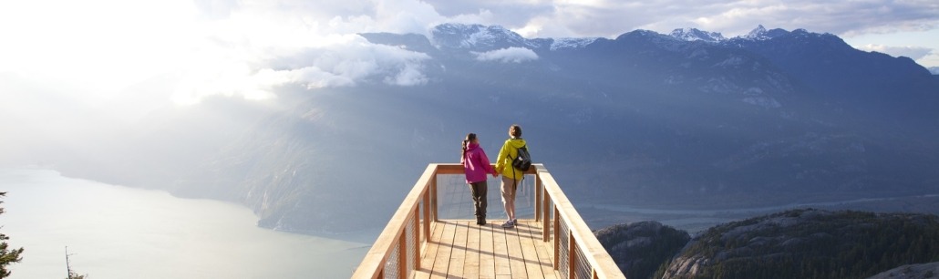
After pausing to admire the panoramic view of glacier-topped mountains and the calm waters of the pine-lined sound far below from several viewpoints and snapping a few pictures on the suspension bridge, you can either continue your adventure on the trails that branch off from the summit, celebrate your ascent with a much-deserved meal or beverage at the restaurant.
Getting back down again is easy – you can download a one-way ticket for the gondola for a smooth, 10-minute ride back to the base and avoid the steep inclines you faced on the way up.
If you like the punishment of the 918 meter gain in reverse, you can always take the Sea to Sky Summit Trail back down again or venture back via the Shannon Basin Loop, although it’s not much easier. This climb is very rewarding, but not for everyone. Ropes and chains are built-in throughout the trail, so you need enough strength to use them to climb or pull yourself up over boulders or steep patches. Be sure to take plenty of breaks and bring snacks and water.
Sea to Summit Hike Details:
- Dog Friendly: Yes (Dogs can also ride on the Sea to Sky Gondola. A Leash is required at all times.)
- Season: March to November
- Public Transit: Sea to Sky Gondola shuttle
- Difficulty: Advanced (Intermediates may be able to do the hike, but ropes and chains are built in at parts and scrambling is required.)
- Time: 3-5 hours
- Distance: 9.8 km one way
- Elevation Gain: 918 m
Getting To the Sea to Summit Trail
Head south from Squamish on the Sea to Sky Highway for about 10 minutes and park at the base camp for the Sea to Sky Gondola on the left side of the road. From the parking lot, follow the signs for the trail, which starts as part of the Stawamus Chief Trail. Normally, you have to cross the Oleson Creek Bridge to reach it, which was recently closed. You can continue on, but proceed at your own risk. To avoid this obstacle, simply park at the Chief Trailhead to start the hike.


Leave a Reply
Want to join the discussion?Feel free to contribute!